Tales of a 21st Century Gypsy

November 16, 2005. Mulanje Mountain.


My work in Malawi is all about a mountain. Mulanje Mountain, to be precise. I’ve been reading about this mountain, thinking about it, talking about it, looking at it, hearing about it, since June. But I hadn’t been up it. I wanted to go, but I also thought it was kind of a boondoggle, just a hiking trip that I should do on my own time, not when I was getting paid to work on my economic analysis.


Then one day I changed my mind. All of a sudden, it seemed that I had to actually see what was up there, know with my own eyes what we are trying to protect, see what the fires do to the landscape, encounter the people illegally cutting cedar, stay in the huts I kept hearing about. I wanted to walk the whole plateau, going up on the western edge from Likhabula and walking for a few days to come down the Ruo Gorge behind the Lujeri tea estates.


Mulanje is, I think, properly called an escarpment, though I’m not sure what that means. Its steep south western face juts out of the fairly flat land below, rising 2000 meters in a sudden wall of rock. Mulanje Boma, the town where the district government is based, is at the bottom of the mountain’s face. The paved road connecting Blantyre to the Mozambican border runs along the foot of the mountain, and a mile of recently tarred dirt road heads up the mountain through the boma. (The word “boma” is used to refer to local government seats in Malawi, as if it were a Chichewa word for city hall or provincial capital. But actually it’s an English acronym for British Overseas Military Administration.) The road dead ends at the lodge where I stay when I’m in Mulanje. Above the lodge is a path heading up the mountain, with a sign warning that it is very steep and dangerous in case of rain.

The escarpment is wider than it is deep – from northwest to southeast it runs for something like twenty kilometers, but in the other direction only five or six. At 2000 meters there’s a kind of a plateau, with gentle rolling hills. Rising from the plateau

is a series of peaks, of which the tallest, Sapitwa, just clears 3000 meters. The forests we’re trying to protect are – or perhaps I should say were – on the plateau and the steep slopes leading up to it. I had no intention of scaling any of the rocky peaks, but at least I wanted to see what that plateau was all about.


I went up with Julian, the ecologist from MMCT – the Mulanje Mountain Conservation Trust, based in Mulanje Boma – and Paul, a Scotsman visiting Malawi to gather or a funding proposal to the Scottish Executive. We took three porters with us to carry our bags. I’d thought that finding porters might be tricky, or that it might be awkward to have these men carry out things for us. Finding them was easy, though – as we neared the forest young men chased our car up the road, asking to work for us. At the trailhead, two Forest Department staffers brought out a list of porters; it turns out they must take turns, so everyone gets a chance at this rare but relatively lucrative work. A fight broke out about whose turn it was to work; the 600 kwachas - $4.50 - plus food that we pay per day is a lot for these men. So I stopped feeling guilty. Not taking porters would have been a great unkindness on our part, not a respected decision to take responsibility for ourselves.


Climbing Mulanje was much harder than I’d expected. I’d been working hard in the gym, an hour a day on the treadmill at its steepest setting, which I figured would be good training for going up the mountain. I should have been running stairs instead, up and down, that’s more what climbing the mountain was like. It took us four hours to go up, with a few stops to admire the view, and a longer stop while Julian investigated a pair of pit sawyers cutting live cedar trees.

But perhaps I need to explain about the cedar. Mulanje Mountain is home to a unique species of cedar, called, not surprisingly, the Mulanje Cedar. In the past, they grew in thick groves, and visitors wrote of smelling their strong scent before they even saw them. The cedar is used to make furniture and tourist items - boxes, picture frames, CD holders, and the like. Paul and I bought carved cedar walking sticks to help us up the mountain, from an eager artisan in Likhabula. The cedar is the national tree, and its harvest is tightly controlled, at least on paper. For the last few years there was no cedar cutting season at all, but this year the Forest Department issued permits to cut dead trees. That’s not much of a restriction – around a third of the cedars on the mountain are dead, according to a recent MMCT study, the victims of fire, drought, and murder.


Yes, murder. Since only dead trees can be cut, unscrupulous cutters will ring the bark around prize trees to kill them, so they will be available for cutting in future years. You go figure.

Most cedar – dead as well as live – is cut without a permit anyway. The curio vendors at the Forest Department in Likhabula, whom I interviewed in the course of my work, assured me that they only buy legally cut cedar. The Forest Department staff told me otherwise, though, and I’m sure they are right. So by buying our walking sticks there, we were contributing to the destruction of the resources we are working to save. On the other hand, the carvers in that area had spent hours answering my questions a week

earlier, and they were quite open about how they operate, their costs, and the prices they charge. So I thought I kind of owed it to them to buy some of their wares as a thank you for their information. MMCT is hoping to set up some kind of “sustainably harvested cedar” certification for the curio trade, but until that happens, there’s no way to ensure you’re buying permitted cedar.

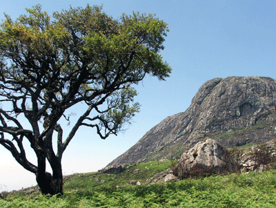
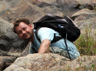
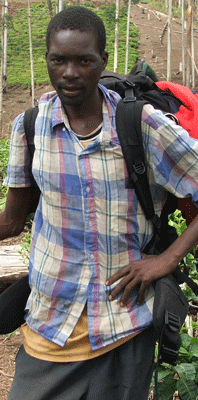
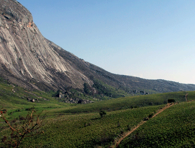
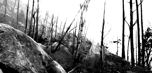
So Paul and I pushed ourselves up the mountain on our illegal walking sticks, enjoying their illicit scent. We didn’t go up from Likhubula, as none of us had time to traverse the whole plateau. Instead, we headed up what’s called the Sombani trail, which runs up the eastern side of the escarpment. It was hard, but definitely worth the climb. The plateau, when we reached it, was quiet and peaceful, gentle green hillsides and a huge open sky. Paul said it reminded him of the Scottish landscape, hardly what he expected from Mulanje. I liked the open space. The climb up had been through forests and the charred ruins of forests, but nothing blocked the view on the plateau. We were the only people for miles around, and the only noise was the breeze and the birds and the insects. It was a very calming place.

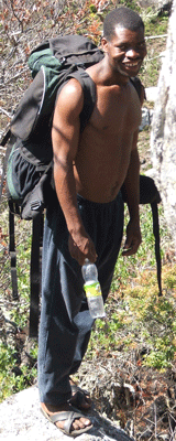
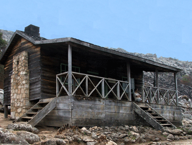
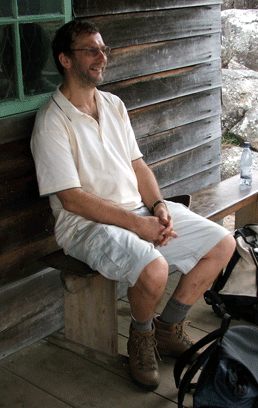
We spent the night at Sombani hut, one of a network of huts that used to be summer cottages of wealthy expats but are now maintained for hikers by MMCT, the Forest Department, and the Mulanje Mountain Club. These are real cottages – not the misnamed mansions of the 19th century robber barrons outside of New York City or the obscene new ten-bedroom monstrosities lining the beaches of North Carolina’s Outer Banks. Sombani hut has two rooms, a stone fireplace and chimney, and a porch. We cooked our dinner in the fireplace, and Paul, Julian and I all set up our camp beds – stored in the hut for Mountain Club members – on the porch to sleep outside. Each hut is maintained by a warden who lives there. He brought us water from the stream, heated it for us to shower, and brought us fuelwood for our fire. Our porters slept and ate with him, sharing the food we had brought for their dinners and breakfasts. It was strange to be waited on, but also nice not to have to worry about water or firewood – luxurious, for a simple place to stay. The moon was nearing full, and it rose behind our outdoor beds in the evening, lighting the plateau and the peak opposite us.

The next day we split up, Julian heading straight down with one of the porters while Paul and I took a different route with the other two. The couple of miles on the plateau to our downward trail were lovely, up and down the gentle hills, with the peaks towering above us. The climb down was hard, though, at least for me. It was steeper than the route up, jumping down rocks and in places

slithering down ladders where the rocks were too steep to walk down. For a while it was fine, but then my legs balked at any more steps down, and I went slower and slower, while Paul and the porters raced ahead. It was, to put it bluntly, Not Fun. And it went on forever, it seemed, especially as the porters kept assuring me there was just a little way, when in fact we were still miles from the bottom. In places I simply wanted to give up, but that wasn’t an option. So plodded on, even steep dusty slope because I just couldn’t control my legs well enough to scamper down it the way the porters did.


But at the bottom we hit a rushing cool stream, which almost made up for it. I sat down up to my waist in water, poured bottles of water on my head, and drank bottles of water straight from the stream. (Mulanje water is famously clean.) It was heavenly. After half an hour I had finally cooled down, and regretfully put my shoes back on for the last half-hour walk through a tea-growing village to where our driver had been waiting for us for hours.

I’m glad I went up Mulanje. I’m not at all sure I’d do it again, though, at least not without a lot more training on stairs before I go. And while it was beautiful to be here, it was discouraging in terms of my work. Everything up there

has been burned. The open spaces that I so enjoyed were open in part because the vegetation there had been destroyed by fire, and replaced with the lush ferns that spring up in disturbed places. Everyplace we walked the ground was black from fires set to encourage new growth that might attract grazing animals. On the slopes, scarred skeletons of burnt trees dotted the landscape. We scarcely saw a healthy cedar; instead we hit a group of workmen blithely assuring us that they had a

permit to clear-cut the few thatremain alive. We did see one good-sized animal, a klipspringer, and scat from a few civet cats. But this is a place that used to be teeming with wildlife and fearful from leopards. As long as the threatened bauxite mining on the northwestern end of the plateau doesn’t come to pass – and it doesn’t look likely – the mountain won’t be going away. But it seems like everything else that made it special is almost gone.

Continue to the next entry. Return home.

Photo of Joy Hecht by Paul Shaw. All text and all other photos on this site ©Joy E. Hecht.